

To use a marine compass, you must align the fixed lubber’s line with the bow of your vessel and read the numeric degree marked on the rotating compass card that sits directly beneath it. This reading represents your magnetic heading, which is the direction your boat is currently pointed relative to the Earth’s magnetic north pole. While a GPS provides your track over ground, the compass is the only tool that shows the physical orientation of your hull, making it the primary instrument for steering a steady course through waves, wind, and current.
Use the Lubber’s Line as Your Fixed Reference Point
The lubber’s line is the permanent vertical mark or pointer inside the compass housing that represents the longitudinal axis of your boat. When you look at your compass, you are not looking at a moving needle like a hiking compass; instead, you are looking at a floating card that stays oriented to the North while the boat—and the lubber’s line—rotates around it. To determine your direction, you simply look at which number on the card is aligned with this line.
Marine Compass and Navigation Tools

Marine Compass, Car Marine Navigation Compass with Adjustable Mounting Bracket, Car Marine Accessories, Marine RV Truck Accessories
Marine Compass, Car Marine Navigation Compass with Adjustable Mounting Bracket, Car Marine…
VIEW LATEST PRICE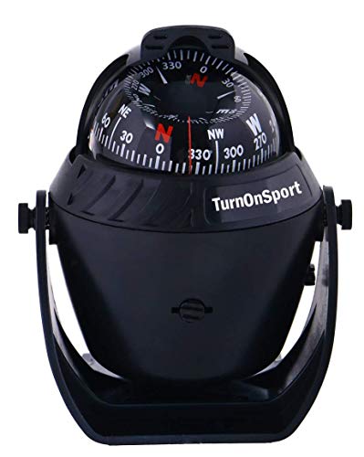
Boat Compass Dash Mount Flush – Boating Compass Dashboard Suction – Navigation Marine Compass Boats Surface Mount – Illuminated Dashboard Compass Ship – Electronic Sea Compass Suction Cup (Black)
Boat Compass Dash Mount Flush – Boating Compass Dashboard Suction – Navigation…
VIEW LATEST PRICE
Black Electronic Adjustable Ball Night Vision Compass for Boat, Vehicle, Marine – 56x65x80mm, 98g, with Adhesive Mount & Lubber Line – Ideal for Boats, Trucks, Caravans
Black Electronic Adjustable Ball Night Vision Compass for Boat, Vehicle, Marine –…
VIEW LATEST PRICEFor the lubber’s line to be accurate, the compass must be mounted so that the line is perfectly parallel to the centerline of the keel. If the compass is mounted at an angle, every reading you take will be offset by that same number of degrees. This is known as an installation error, and it can lead to significant navigation mistakes over long distances.
When steering, your goal is to keep the desired heading degree mark aligned with the lubber’s line. If the mark for 090 (East) moves to the left of the lubber’s line, it means your boat’s bow has swung to the right (South), and you need to steer back to the left to realign them. Understanding that the card stays still while the boat moves is the first step in mastering marine navigation.
Read the Compass Card to Identify Your Magnetic Heading
Marine compass cards are divided into 360 degrees, with cardinal points—North (0°), East (90°), South (180°), and West (270°)—clearly marked to provide immediate orientation. Most high-quality marine compasses use 5-degree increments for their markings, though some larger models feature 2-degree increments for finer precision. Because you are often viewing the compass from an angle or in rolling seas, the card is mounted on a pivot and submerged in a damping fluid, typically a highly refined mineral oil, to prevent the card from spinning wildly or bouncing.
When reading the card, it is vital to maintain a consistent eye level to avoid parallax error. Parallax occurs when you view the lubber’s line and the compass card from an offset angle, making it appear as though the line is pointing to a different degree than it actually is.
- Top-mount compasses: Usually found on powerboats, these are read from above or at a slight downward angle.
- Bulkhead-mount compasses: Common on sailboats, these are read from the side and often include dual scales for reading from the cockpit or the cabin.
Learning to read the card quickly allows you to spend more time looking at the horizon and less time staring at the binnacle, which helps prevent motion sickness and improves situational awareness.
Account for Magnetic Variation to Align with True North
Magnetic variation is the angular difference between the Magnetic North Pole (where your compass points) and the True North Pole (the geographic axis of the Earth). Because the Earth’s magnetic fields are not uniform and shift over time, your compass will rarely point to True North. According to basic navigation principles, variation changes depending on your specific geographic location on the globe.
To find the variation for your area, you must consult the compass rose on a local nautical chart. The compass rose typically features an outer circle showing True North and an inner circle showing Magnetic North. Inside the center of the rose, you will find a statement such as “Variation 12°W (2024) – Annual Increase 4′.”
To convert a Magnetic heading to a True heading:
- Identify the local variation: Find the nearest compass rose on your chart.
- Add or Subtract: If the variation is East, you add it to your magnetic heading to get True. If the variation is West, you subtract it.
- The Mnemonic: Many sailors use “Variation East, Magnetic Least” (meaning Magnetic is smaller than True) and “Variation West, Magnetic Best” (meaning Magnetic is larger than True).
Failure to account for variation can result in a cross-track error that grows the further you travel. In parts of the Pacific Northwest or the North Atlantic, variation can exceed 20 degrees, which would put a vessel miles off course in a single afternoon.
Neutralize Compass Deviation Caused by Onboard Equipment
Deviation is the error introduced to your compass by local magnetic fields within your own boat, such as engine blocks, wiring, and electronics. Unlike variation, which is the same for every boat in a specific area, deviation is unique to your vessel and changes depending on which direction the boat is pointed. For example, your compass might be accurate when heading North, but off by 5 degrees when heading West because the engine is suddenly positioned differently relative to the Earth’s magnetic field.

Electrical equipment is a primary source of deviation. Items like speakers, windshield wiper motors, and even your handheld marine VHF radio contain magnets or create electromagnetic fields that can “pull” the compass card away from North.
To manage deviation, professional mariners use a “Deviation Table” or “Compass Card.” This is a list of corrections for every 15 or 30 degrees of heading.
- Swinging the Compass: This is the process of turning the boat in a slow circle and comparing the compass reading to a known “clean” reference (like a handheld GPS or a range of two landmarks) to see how much the compass deviates on each heading.
- Internal Compensators: Most fixed marine compasses have two small adjustment screws (labeled B and C) that allow you to move internal magnets to cancel out some of this local interference.
Apply the TVMDC Formula for Precise Course Calculations
The TVMDC formula is a standardized method for converting between the course you draw on a paper chart and the heading you actually steer on your compass. It stands for True, Variation, Magnetic, Deviation, and Compass. Navigators use the mnemonic “True Virgins Make Dull Company: Add Whiskey” to remember the order and the rule for adding West errors.
| Step | Component | Action (Chart to Compass) |
|---|---|---|
| T | True Course | The line drawn on your chart relative to the North Pole. |
| V | Variation | Add West variation, Subtract East variation. |
| M | Magnetic Course | The course adjusted for the Earth’s magnetic field. |
| D | Deviation | Add West deviation, Subtract East deviation. |
| C | Compass Heading | The final number you steer by on your boat’s compass. |
If you are going from Compass to True (correcting), you reverse the math: Subtract West, Add East. This formula ensures that when you see “090” on your chart, you know exactly what number needs to be under your lubber’s line to actually travel in that direction. In the modern era, many chartplotters do this math for you, but knowing the manual calculation is a critical safety skill if your electronics fail.
Master the Technique of Steering by Compass Without Fatigue
Steering by compass is a skill that requires you to react to the trend of the movement rather than the immediate number on the card. Beginning boaters often “chase the compass,” turning the wheel back and forth every time the card moves a degree. This results in a zig-zagging path (snaking) that wastes fuel and makes passengers seasick.
To steer effectively:
- Look over the bow: Pick a distant object—a cloud, a star, or a point on land—that aligns with your desired heading. Use that as your primary target.
- Glance, don’t stare: Check the compass every few seconds to ensure your “distant object” is still on the correct heading.
- Anticipate the swing: When the boat starts to drift off course due to a wave, apply a small amount of rudder early. If you wait until the compass shows you are 10 degrees off, you will have to oversteer to get back.
- Averaging: In heavy seas, the card will swing back and forth. Do not try to correct for every wave. Instead, try to keep the lubber’s line oscillating evenly around your target heading.
By focusing on the horizon and using the compass as a secondary reference, you reduce eye strain and develop a “feel” for how the boat reacts to the helm.
Fix Your Position Using a Hand-Bearing Compass and Triangulation
A hand-bearing compass is a portable device used to take “bearings” (angles) on landmarks to determine your exact position on a chart. According to West Marine’s guide to bearings, these tools allow you to step away from the magnetic interference of the cockpit to get a cleaner reading.
How to Triangulate Your Position:
- Identify three landmarks: Choose fixed objects shown on your chart, such as a lighthouse, a water tower, and a prominent mountain peak. Ideally, these should be about 60 to 120 degrees apart.
- Take the bearings: Point the hand-bearing compass at the first object and record the magnetic degree. Do this quickly for all three objects.
- Convert to True: Apply the local variation to each bearing.
- Plot on the chart: Use a parallel ruler or a protractor to draw a line from each landmark at the reciprocal angle (the angle + 180°).
- Find the fix: Where the three lines intersect is your current position. Usually, they form a small triangle called a “cocked hat.” Your boat is somewhere inside that triangle.
Triangulation is the gold standard for backup navigation. If your GPS loses signal or your batteries die, a hand-bearing compass and a paper chart are all you need to find your way home.
Mount Your Compass Correctly to Avoid Interference and Parallax
The physical placement of your compass is the most important factor in its long-term accuracy. A compass mounted poorly will provide inconsistent data that can lead to dangerous navigation errors. When choosing a mounting location, you must balance visibility with magnetic hygiene.
Mounting Rules:
- Centerline Alignment: The lubber’s line must be exactly parallel to the boat’s keel. Even a 2-degree offset in the mount will cause a 2-degree error on every heading.
- Distance from Electronics: Keep the compass at least 3 feet away from high-current wiring, electric motors, and large speakers. This includes your fixed mount VHF radio, which has internal speakers with powerful magnets.
- Line of Sight: The helmsman should be able to read the compass without leaning or straining. It should be mounted low enough to be visible while seated but high enough to be seen while standing.
- Stability: Ensure the mounting surface is rigid. A vibrating compass is difficult to read and will wear out the internal pivot jewel prematurely.
After mounting, always perform a “deviation check” to see if the surrounding hardware—like stainless steel rails or steering gear—is affecting the card.
Troubleshoot Common Compass Issues Like Air Bubbles and Sluggishness
A well-maintained marine compass can last decades, but certain issues can degrade its performance. The most common problem is the appearance of an air bubble inside the dome. While a tiny bubble might not affect accuracy, a large bubble can cause the card to tilt or get stuck, rendering the instrument useless.
- Air Bubbles: These usually form because of a leak in the seal or the diaphragm. As the fluid expands and contracts with temperature, air is pulled in. If you see a bubble, the compass needs to be professionally serviced or refilled with the manufacturer-specified fluid.
- Sluggish Movement: If the card takes a long time to settle or seems to “stick,” the pivot or the jewel may be worn or dirty. You can test this by moving a small magnet near the compass to pull the card 10 degrees away, then removing the magnet and seeing if the card returns to its original position quickly and smoothly.
- Discoloration: Sunlight (UV rays) can yellow the fluid or fade the markings on the card over time. Using a compass cover when the boat is not in use is the best way to prevent this.
- Fluid Leaks: If you notice an oily residue around the base of the compass, it indicates a failed gasket. This requires immediate repair, as the fluid is what protects the delicate internal components.
Integrate Your Compass with Digital Navigation and VHF Systems
While the magnetic compass is a standalone analog tool, its data should be used to verify and complement your digital systems. Modern vessels often have a “Heading Sensor” (an electronic fluxgate compass) that sends data to the autopilot and the chartplotter. However, the physical magnetic compass remains your primary “source of truth.”

Verification Steps:
- Cross-Check COG vs. Heading: Compare your Course Over Ground (COG) from the GPS with your Compass Heading. If the COG is 090 but your compass says 100, you are experiencing 10 degrees of “set” (current or wind pushing you sideways).
- Emergency Backup: In the event of a total power failure, your compass is the only thing that will keep you on course. Ensure you know how to use a VHF radio on a boat to call for assistance, but rely on your compass to maintain your position while waiting for help.
- Night Navigation: Use the internal red backlight of your compass for night sailing. Red light preserves your night vision, allowing you to see markers and other vessels while still monitoring your heading.
In modern maritime safety, the compass works as a check against “GPS spoofing” or signal jamming. If your electronic map shows you turning but your magnetic compass stays steady, you know your electronics are malfunctioning.
Reliability Beyond Electronics
The marine compass remains the most reliable piece of equipment on any vessel because it does not rely on satellites, batteries, or complex circuitry. It is a direct link to the physical properties of the Earth. By mastering the ability to read the lubber’s line, calculate variation and deviation, and steer a steady course, you gain a level of seamanship that technology cannot replace.
Whether you are navigating a foggy harbor or crossing an ocean, your compass provides the “ground truth” of your vessel’s orientation. Treat it as your primary instrument, and keep it clear of magnetic interference. When the screens go dark or the signal drops, the floating card in your binnacle will still be pointing the way home, unaffected by anything other than the planet’s own magnetic pulse. For any boater, the transition from being a “GPS follower” to a “navigator” begins with the humble magnetic compass.
📅 Last updated: