

Navigation has evolved dramatically over the centuries, from ancient mariners relying solely on the stars to today’s sophisticated electronic systems.
Two primary navigation tools stand at the forefront of this evolution: the traditional magnetic compass and the modern Global Positioning System (GPS).
Navigation Tools
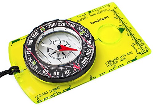
Orienteering Compass – Hiking Backpacking Compass – Advanced Scout Compass for Camping and Navigation – Boy Scout Compass for Kids – Professional Field Compass for Map Reading – Best Survival Gifts
Orienteering Compass – Hiking Backpacking Compass – Advanced Scout Compass for Camping…
VIEW LATEST PRICE
Orienteering Compass Hiking Backpacking Compass | Advanced Scout Compass Camping Navigation – Boy Scout Compass for Kids | Professional Field Compass for Map Reading – Best TurnOnSport Survival Gifts
Orienteering Compass Hiking Backpacking Compass | Advanced Scout Compass Camping Navigation -…
VIEW LATEST PRICE
Magnetic Compass for Kids – Orienteering & Wilderness Survival Navigation Gear, Pocket Hiking Compass for Camping, Backpacking, Hunting, Outdoor Adventure
Magnetic Compass for Kids – Orienteering & Wilderness Survival Navigation Gear, Pocket…
VIEW LATEST PRICEUnderstanding when and how to use each tool effectively can be crucial for anyone from casual hikers to maritime professionals. This comprehensive comparison explores the strengths, weaknesses, and practical applications of both navigational technologies in today’s world.
How does a magnetic compass work for navigation?

A magnetic compass is one of humanity’s oldest navigational tools, utilizing Earth’s natural magnetic field to determine direction. The basic principle behind this deceptively simple device involves a magnetized needle that aligns itself with the Earth’s magnetic field lines, creating a reliable reference point for directional orientation.
Traditional compasses feature a freely rotating magnetic needle suspended over a card marked with cardinal directions (north, south, east, and west). When properly used, the compass needle will show magnetic north, allowing a navigator to determine their heading and orientation regardless of visibility conditions or electronic infrastructure. This fundamental technology has guided explorers, sailors, and travelers for centuries before the advent of electronic navigation systems.
What is magnetic north and how does it affect compass readings?

Magnetic north is not the same as true north (the geographic North Pole). Instead, it refers to the point where the Earth’s magnetic field lines converge in the Northern Hemisphere. This distinction is crucial because a magnetic compass aligns with magnetic north rather than true north.
The difference between these two points, known as magnetic declination or variation, changes depending on your location on Earth and shifts slightly over time due to the movement of Earth’s magnetic field.
For instance, in some parts of the United States, magnetic north can be over 20 degrees different from true north. When using a compass for navigation, especially for long-distance travel or precise positioning, navigators must account for this declination.
Nautical charts and topographic maps typically include declination information, allowing users to make appropriate adjustments to their compass readings to determine true directional headings.
What causes compass deviation and how to correct it?
Compass deviation refers to errors in compass readings caused by local magnetic disturbances rather than Earth’s natural magnetic field. These disturbances can come from various sources, particularly on vessels or vehicles where the compass is surrounded by metal objects, electronic equipment, or electrical currents.
On ships, the ship’s compass can be affected by the vessel’s own magnetic signature, creating consistent errors in heading information. Similarly, when using a magnetic compass near power lines, speakers, smartphones, or even certain types of rocks with high iron content, readings can become inaccurate.
Professional navigators correct for deviation by creating deviation tables or cards that document the error at different headings, allowing them to apply corrections to their compass course. Some high-quality compasses include adjustable compensation magnets that can be calibrated to counteract local magnetic influences.
For accurate navigation, especially in critical situations, understanding and correcting for both declination and deviation is essential to maintain a reliable compass reading and establish a correct compass heading.
How to properly use a compass for basic navigation?
Properly using a magnetic compass for basic navigation involves several fundamental steps. First, hold the compass level and away from any potential sources of magnetic interference such as smartphones, keys, or metal objects.
For basic orientation, allow the magnetic needle to settle and align with magnetic north. The direction of travel arrow on the compass can then be pointed in your intended direction of travel. When using a compass with a map, you’ll need to adjust for magnetic declination by aligning the compass’s orienting lines with the map’s north-south grid lines, then rotating the bezel until the orienting arrow points to the declination-adjusted north.
For navigation using bearings, identify your target, point the direction of travel arrow toward it, and rotate the bezel until the orienting arrow aligns with the magnetic needle.
The reading at the index line provides your bearing. To follow a specific compass course, set the desired bearing on the bezel, then rotate your body until the magnetic needle aligns with the orienting arrow (a technique known as “putting the red in the shed” with red-tipped needles). Walking while maintaining this alignment will keep you on your chosen compass heading.
Regular practice with a map and compass in familiar terrain builds the confidence needed to navigate effectively in more challenging environments without relying on electronic aids.
What are the advantages of GPS navigation over traditional compass?
GPS navigation offers numerous advantages over traditional magnetic compass navigation, fundamentally transforming how we orient ourselves in the world.
Perhaps the most significant benefit is precision and ease of use. While a compass only provides directional information, a GPS receiver delivers exact coordinates showing your current position on Earth with accuracy often within a few meters.
This eliminates the complex calculations and potential human errors associated with traditional map and compass work. Modern GPS devices also provide dynamic information including speed, elevation, estimated time of arrival, and even three-dimensional positioning.
Additionally, GPS navigation works in all weather conditions and times of day, requiring no visibility of landmarks or celestial bodies that traditional navigation might depend on. The learning curve for basic GPS navigation is also considerably shorter than mastering compass navigation techniques, making it more accessible to novices.
The integration of digital maps, waypoints, routes, and track recording further enhances the GPS advantage, allowing users to plan, document, and share their journeys with unprecedented detail and convenience.
How do GPS satellites determine your position?
The Global Positioning System relies on a constellation of at least 24 GPS satellites orbiting Earth at an altitude of approximately 20,200 kilometers.
These satellites continuously broadcast precise time signals and orbital information (ephemeris data) that GPS receivers on Earth can detect.
When your GPS unit receives signals from multiple satellites (ideally four or more), it performs a complex mathematical operation called trilateration to determine your exact position.
This process measures the time it takes for each satellite signal to reach your receiver, calculating the distance to each satellite based on the speed of light. With distances from multiple satellites, your GPS receiver can pinpoint your location in three dimensions—latitude, longitude, and altitude.
The entire GPS system depends on incredibly precise atomic clocks aboard each satellite that are synchronized to within nanoseconds. Even a microsecond error could result in position errors of hundreds of meters.
The U.S. Department of Defense originally developed this satellite network for military applications, but it now serves billions of civilian users worldwide. The system requires signals from a minimum of three satellites to determine a 2D position (latitude and longitude) and at least four satellites for a 3D position including altitude—though modern receivers typically track 8-12 satellites simultaneously for improved accuracy.
What features do modern GPS devices like Garmin offer?
Modern GPS devices, with Garmin being one of the leading manufacturers, offer an impressive array of features that extend far beyond basic positioning.
Today’s handheld GPS units combine powerful processors with advanced software to provide comprehensive navigational tools. Most Garmin devices include preloaded topographic maps with options to add detailed regional maps, marine charts, or street maps depending on your intended use.
Many units feature high-resolution color displays with touchscreen interfaces, making interaction intuitive even in challenging outdoor conditions. Advanced routing capabilities allow users to plan trips with multiple waypoints, follow established trails, or create custom routes.
Many GPS devices now incorporate electronic compass functionality that works even when stationary (unlike traditional GPS navigation that requires movement to determine direction). Barometric altimeters provide more accurate elevation data than GPS-derived altitude alone.
Higher-end Garmin models offer wireless connectivity for sharing routes with other devices, downloading weather updates, or connecting to smartphones for notifications.
Specialized features for specific activities might include tide tables for marine chart plotters, geocaching databases for treasure hunters, or hunting-specific mapping showing property boundaries.
Battery management has also improved significantly, with many devices offering battery life of 20+ hours and options for replaceable batteries or external power connections for extended expeditions.
When is GPS more reliable than a magnetic compass?
GPS navigation proves more reliable than a magnetic compass in numerous scenarios, particularly in environments with magnetic anomalies that would disrupt compass readings.
Areas with high concentrations of ferrous minerals or near significant metal structures can render magnetic compasses unreliable due to deviation, while GPS signals remain unaffected by these magnetic disturbances. In unfamiliar terrain without visible landmarks, GPS excels by providing absolute positioning rather than just directional information, allowing travelers to pinpoint their location on digital maps even when disoriented.
On large bodies of water without visual reference points, mariners can navigate with confidence using GPS chart plotters rather than relying solely on compass bearings that could accumulate errors over distance.
In fog, darkness, or adverse weather conditions that might obscure sighting points needed for traditional compass navigation, GPS continues to function accurately. When traveling through featureless environments like deserts or open plains where taking bearings to landmarks is impossible, GPS provides constant position updates.
Additionally, GPS offers superior reliability for maintaining complex routes with multiple turns and waypoints, as it can alert users when approaching turn points and automatically recalculate if they deviate from the planned path.
For those without extensive navigational training, GPS systems with intuitive interfaces provide accessible navigation that would otherwise require significant skill with map and compass techniques.
What are the limitations of using GPS for navigation?
Despite its technological sophistication, GPS navigation comes with significant limitations that every navigator should understand. Unlike a magnetic compass, which operates independently, GPS requires a complex infrastructure of satellites and receivers to function.
This dependency creates several vulnerabilities in the system. GPS receivers need an unobstructed “view” of the sky to communicate with satellites, making them less reliable in dense urban environments with tall buildings, deep canyons, thick forest canopies, or caves where signals can be blocked or reflected.
The electronic nature of GPS devices introduces concerns about durability in harsh conditions—exposure to extreme temperatures, moisture, or physical impact can damage sensitive components. Additionally, GPS units require a power source, either batteries or connection to a vehicle’s electrical system, creating a fundamental vulnerability absent in traditional magnetic compasses.
This reliance on power means that GPS devices can fail at critical moments due to battery depletion, especially in cold weather which accelerates battery drain. Another limitation is signal integrity—GPS signals can be susceptible to jamming (intentional interference) or spoofing (false signal generation), which presents security concerns for critical navigation.
Finally, there’s a skill degradation risk—overreliance on GPS technology can lead to atrophy of fundamental navigation skills, leaving users vulnerable when technology fails.
How do battery life and signal coverage affect GPS reliability?
Battery life represents one of the most critical limitations of GPS navigation, creating a fundamental vulnerability absent in traditional compasses. Most handheld GPS units offer battery lifespans ranging from 8-25 hours depending on model, settings, and environmental conditions.
Cold weather significantly reduces battery performance, sometimes by 50% or more, creating a particular concern for winter expeditions or high-altitude navigation. Backcountry travelers must carefully manage power by reducing screen brightness, limiting satellite checks, or carrying spare batteries or portable chargers.
Signal coverage presents another reliability challenge, as GPS receivers require line-of-sight connections with satellites. In deep valleys, urban canyons, dense forests, or caves, satellite visibility becomes restricted, leading to position errors or complete signal loss.
Certain geographic regions, particularly near the poles or in very remote areas, may experience poorer satellite geometry (dilution of precision), reducing accuracy. Weather conditions rarely affect GPS signals directly, but heavy cloud cover or precipitation can marginally degrade performance.
Additionally, the availability of augmentation systems that improve GPS accuracy (like WAAS in North America) varies geographically. Users must account for these limitations by carrying backup navigational tools and understanding how to navigate during GPS outages.
Professional navigators often implement power management strategies like scheduled GPS checks rather than continuous tracking, supplemented with traditional compass and map techniques.
What happens when GPS signals are blocked or jammed?
When GPS signals become blocked or jammed, the consequences range from inconvenient to potentially life-threatening depending on the circumstances and the navigator’s preparedness.
Signal blockage occurs naturally in environments where physical barriers prevent satellite signals from reaching the GPS receiver—dense forest canopies, deep canyons, caves, or urban environments with tall buildings create “urban canyons” that significantly degrade GPS performance. In these situations, a GPS unit might display increasing position errors, freeze on the last known location, or simply indicate “poor satellite reception.”
More concerning is intentional signal jamming, which occurs when devices broadcast interference on GPS frequencies. Such jammers, while illegal in most countries, are relatively inexpensive and accessible. Military operations, certain high-security facilities, and increasingly, criminal activities may involve GPS jamming that affects civilian users in surrounding areas.
When signals are jammed, GPS receivers typically lose positioning ability entirely without warning. GPS spoofing represents an even more sophisticated threat, where false signals trick receivers into displaying incorrect positions—a vulnerability that has affected marine vessels and has national security implications.
Without GPS, navigation systems dependent on satellite positioning fail: vehicle navigation systems lose positioning, marine chart plotters can’t display vessel location, and smartphones lose location-based functionality.
In these situations, having a traditional magnetic compass and the skills to use it becomes invaluable. Professional navigators and outdoor enthusiasts practice “degraded mode” operations, maintaining situational awareness and position tracking even when using GPS, so they can transition to alternate methods when electronic systems fail.
Are there accuracy issues with GPS in certain environments?
GPS accuracy varies significantly across different environments, with several factors contributing to potential positioning errors. In optimal conditions with clear sky view and good satellite geometry, consumer GPS devices typically achieve accuracy within 3-5 meters.
However, this precision deteriorates in challenging environments. Urban settings with tall buildings create “multipath errors” when satellite signals reflect off structures before reaching the receiver, causing position calculations to use incorrect signal timing. These reflections can result in position errors of 10-50 meters or more.
Dense forest canopies attenuate satellite signals, reducing the number of satellites tracked and degrading position quality. High mountains or deep valleys limit the visible sky, creating poor satellite geometry that reduces accuracy along certain axes. Atmospheric conditions also influence GPS performance—ionospheric disturbances, particularly during periods of high solar activity, can introduce errors by affecting signal propagation.
Water presents unique challenges for GPS accuracy; while open water environments offer excellent satellite visibility, the proximity to water can sometimes create multipath effects from signal reflections off the surface. Certain geographic regions, particularly at very high latitudes near the poles, experience reduced accuracy due to satellite orbit configurations that result in fewer satellites visible near the horizon.
Professional users in environments requiring high precision often employ differential GPS techniques or augmentation systems like WAAS (Wide Area Augmentation System) to improve accuracy, but these enhancements may not be available in remote areas. Understanding these environmental limitations helps navigators determine when to rely on GPS and when to supplement with traditional navigational methods.
When should you use a compass vs GPS for outdoor navigation?
The decision to use a compass versus GPS for outdoor navigation should be guided by several key factors including environmental conditions, journey complexity, and personal skill level.
A magnetic compass excels in scenarios where reliability and simplicity are paramount—particularly in emergency situations where electronic devices might fail. Traditional compass navigation shines in environments with strong magnetic fields that remain consistent despite local conditions, making it ideal for basic directional orientation in almost any setting.
Conversely, GPS navigation offers advantages when precise positioning, complex routing, or tracking capabilities are needed. When navigating through featureless terrain like deserts, open water, or snow-covered landscapes where landmarks are scarce, GPS provides critical position confirmation that compass alone cannot.
The duration of your journey also influences tool selection—extended expeditions might exceed battery capacity of GPS devices, making compass reliability essential. Weather considerations play a role too; in severe conditions that might damage electronic equipment, a waterproof magnetic compass continues functioning. The best approach typically combines both tools: using GPS for precise positioning and complex navigation while maintaining compass skills as a fundamental backup.
This hybrid approach ensures navigational redundancy while leveraging the strengths of both traditional and modern technologies.
Which navigation tool is better for wilderness survival?
In wilderness survival scenarios, where reliability under adverse conditions becomes paramount, a magnetic compass generally offers superior dependability compared to GPS technology.
The fundamental advantage of a compass in survival situations is its operational simplicity—it requires no batteries, contains no sensitive electronics, and continues functioning regardless of weather conditions or duration in the field.
A quality magnetic compass can withstand extreme temperatures, submersion in water, and physical impacts that would render most electronic devices inoperable. In genuine survival scenarios, power conservation becomes critical, and the infinite operational life of a compass provides psychological security not available with battery-dependent devices.
Additionally, the compass’s immunity to signal interference ensures it remains functional in all geographic locations, including deep canyons, caves, or dense forests where GPS signals might be unreliable or completely absent.
While GPS offers more precise positioning, survival navigation often requires only general directional guidance to reach safety—precisely what a compass provides. Survival experts consistently recommend compasses as primary navigation tools because they eliminate technological vulnerabilities at times when simplicity and reliability matter most.
That said, the ideal wilderness survival approach incorporates both tools: using GPS for precise positioning when operational, while maintaining compass skills for situations when electronic navigation fails.
This redundancy, combined with map reading proficiency and natural navigation techniques like celestial orientation, creates a comprehensive survival navigation strategy that doesn’t depend exclusively on any single method.
📅 Last updated: